|
|
| Mesoscale Discussion 443 |
|
|
 |
Mesoscale Discussion 0443
NWS Storm Prediction Center Norman OK
0931 PM CDT Tue Apr 27 2021
Areas affected...Northwest Kansas and Southwest Nebraska
Concerning...Severe Thunderstorm Watch 114...
Valid 280231Z - 280330Z
The severe weather threat for Severe Thunderstorm Watch 114
continues.
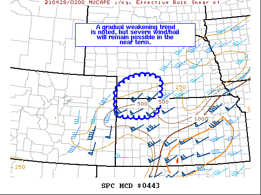
SUMMARY...A gradual weakening trend is noted in the line of storms
moving across northeast Kansas. However, severe hail and wind will
remain possible for the next few hours across Watch 114.
DISCUSSION...A convective line continues to move to the
east/northeast across northwest KS and into far southwest NE.
Several severe wind and hail reports have been noted with this line,
and MRMS echo tops show stronger embedded pulses that will continue
to pose a hail threat in the near term. Additionally, the strong
low-level shear (around 40-50 knots of 0-3 km bulk shear per RAP
mesoanalysis) oriented nearly orthogonal to the cold pool will
continue to support a damaging wind risk. However, IR trends over
the past hour have shown a gradual warming trend in cloud top
temperatures, suggesting that the overall intensity of the line may
be waning as it migrates towards the northern fringe of the more
favorable instability and towards a more capped environment. In
general, this trend is expected to continue over the next few hours
and the severe risk will likely become confined to stronger impulses
embedded within the line - most likely along the KS/NE state line
where the instability/shear parameter space will remain most
favorable for organized convection.
..Moore.. 04/28/2021
...Please see www.spc.noaa.gov for graphic product...
ATTN...WFO...GID...LBF...GLD...
LAT...LON 39360197 40000204 40500197 40940125 41090018 40859948
40249952 39699957 39249991 39220073 39230162 39360197
|
Top/All Mesoscale Discussions/Forecast Products/Home
|
|
Like this:
Like Loading...
Related


